Map of anthrax burials compiled from open data: Ministry of Agriculture refused to disclose them
Pavlov Analytics mapped open data: 625 locations, 2-4 km accuracy.
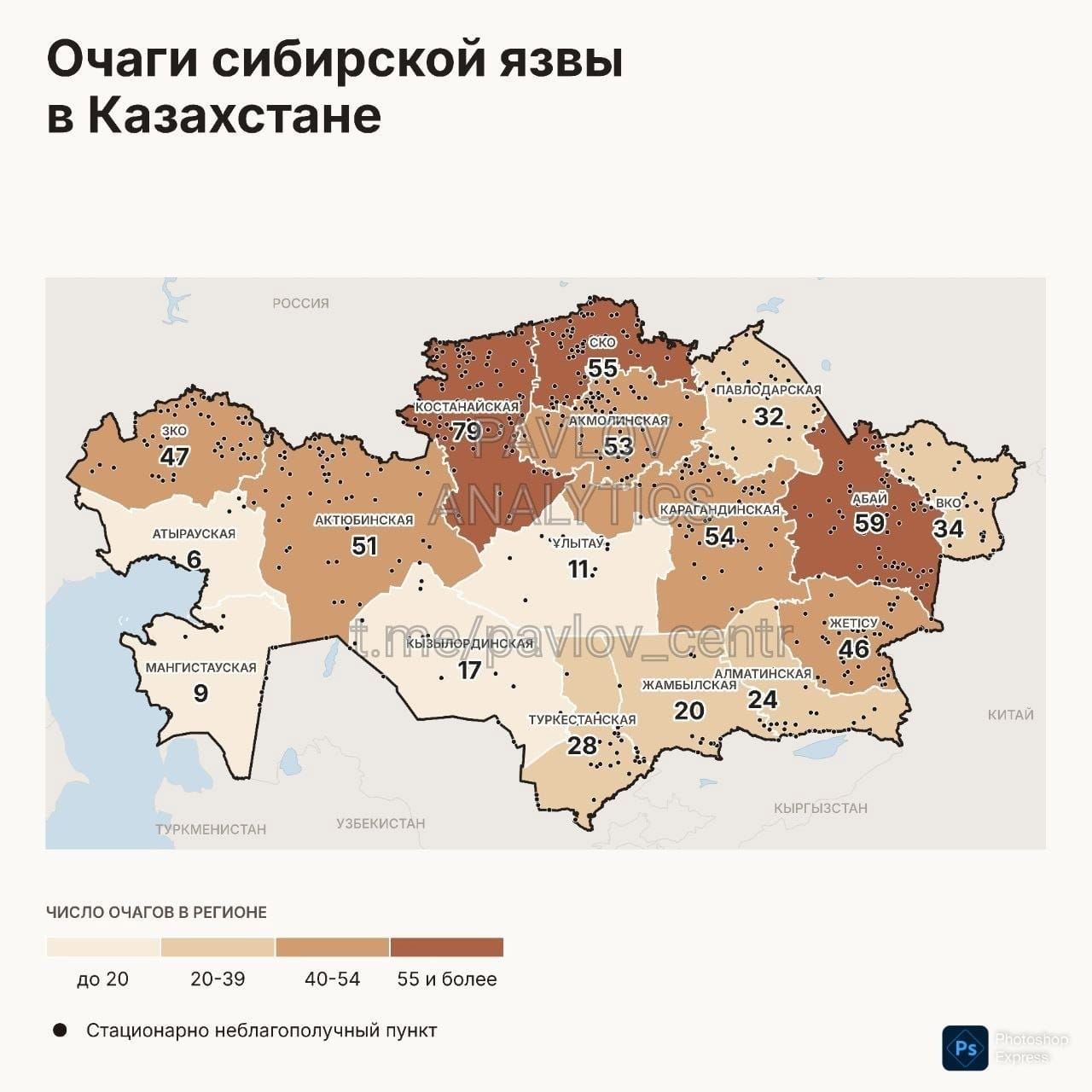
There is no public map of anthrax burials in Kazakhstan, FBRI writes. The Ministry of Agriculture responded to the editorial team's request that information about them is classified as "For Official Use" (FOU).
The gist in brief
- The Ministry of Agriculture refused to provide the Anti-Corruption Investigation Bureau Foundation (FBRI) with information about anthrax burials: Vice Minister Amangali Berdalin responded that they are included in the list of documents marked FOU. FBRI filed a complaint with the Ministry of Agriculture and appealed to the Ministry of Culture and Information.
- The Pavlov Analytical Center compiled a map of 625 sites, linking it to the National Atlas "Anthrax Foci" for 1948-2004; the margin of error is 2-4 km.
- The most sites are in Kostanay (79), Abai (59), North Kazakhstan (55), Karaganda (54), and Akmola (53) regions.
- The Ministry of Agriculture cited different figures: 2034 burials in June 2016, 2604 sites in July 2016, and 2560 burials in 2025 (according to FBRI); according to Pavlov, by early 2026 the figure was already more than 3000.
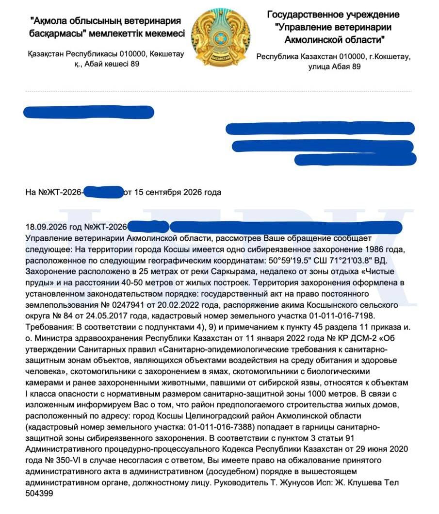
- The reason for the investigation was a 1986 burial in Kosshy: according to the Akmola Region Veterinary Department, it is located 25 m from a river and 40-50 m from residential buildings, with a required sanitary zone of 1000 m.
What the Ministry of Agriculture responded
In FBRI's article, it is stated that the editorial team asked the ministry specific questions: how many anthrax burials are registered, how many of them comply with regulations, where they are located, whether the law permits such objects to be near residential buildings, and what is known about the burial in Kosshy. According to FBRI, the vice minister's response contained no figures, no addresses, and no mention of Kosshy — only a statement that the information is included in the list of documents marked FOU.
The editorial team sent a complaint to the ministry and appealed to the Ministry of Culture and Information with a request to assess the legality of the refusal. FBRI's article does not provide responses to these appeals.
FBRI founder Kirill Pavlov wrote in a Telegram channel that the vice minister did not refute the information about the houses in Kosshy, and his attempt to evade an answer "turned out to be more eloquent than a confirmation." According to him, anthrax spores live in burial sites for more than a hundred years.
The editorial team's legal argument: The Environmental Code classifies environmental information as publicly accessible and not subject to restriction or classification, and the same principle is enshrined in the Aarhus Convention.
The FOU classification on the map is not new. In September 2020, then Vice Minister of Agriculture Nurbek Dairbekov, as reported by Liter.kz, said that the map of anthrax burials was developed jointly with other government agencies, is stored in the Ministry of Internal Affairs, and is an official-use document, meaning it is inaccessible to the general public.
How it started: Kosshy
The trigger was FBRI's publication about residential houses in Kosshy built within the sanitary zone of an anthrax burial: information about the burial was received by the editorial team's anonymous bot. While the editorial team was waiting for the ministry's response, the Akmola Region Veterinary Department reacted to the questions.
It confirmed that there is one anthrax burial from 1986 in Kosshy. It is located 25 meters from the Sarkyrama River, near the "Chistye Prudy" recreation area, and 40-50 meters from residential buildings. Such objects belong to hazard class I with a sanitary zone of 1000 meters, and the planned residential construction area, according to FBRI, falls within its boundaries.
What the Pavlov Analytics map shows
The center linked the burial map to the National Atlas "Anthrax Foci" for 1948-2004 and obtained 625 sites with a margin of error of 2-4 kilometers. According to Pavlov, this is roughly a quarter of what is listed in the cadastre: the rest merged into solid spots on the atlas sheet that cannot be separated.
According to the center, in the East Kazakhstan region, out of 101 burials, 95 are maintained in violation of regulations. In Tarbagatai district, a residential house stands 250 meters from a burial ground, in Kurchum district a school is 650 meters away, with a required minimum of one kilometer. This regional data is not new: it was previously released by the East Kazakhstan Anti-Corruption Service. In the Zhetisu region, according to the center, 33 burials turned out to be unowned. In Baiserke, the sanitary zone covers part of the village, and in Tlendieva, 429 houses fell within it. Pavlov advises against buying housing in dangerous zones.
What figures the Ministry of Agriculture cited
The total number of burials has been cited differently over the years. On June 28, 2016, Vice Minister Gulmira Isayeva at a meeting on an anthrax outbreak in the Karaganda region stated:
"We have 2034 anthrax burials across the republic."
According to her, 734 of them are not fenced and have no identification markers.
A month later, on July 25, 2016, the ministry's press service reported that 2604 permanently anthrax-affected sites are registered in the country. The exact location has been established for 1890 of them, while for 714 (27.4%) it has not; out of the 1890 sites, 702 (37.1%) are not fenced or have no identification markers. The wording in these publications differs (burials and permanently affected sites), so a direct comparison of the figures requires caution.
On July 26, 2017, the ministry reported that 2612 burials have been established in the country, and information about them has been entered into the State Land Cadastre information system. In 2025, as FBRI writes, the ministry reported 2560 registered burials. According to Pavlov, by early 2026 the figure was already more than 3000, and the location of 350 burials has not been found at all. A public map, as FBRI and Pavlov note, was promised by the agency back in 2016, and later it stated that access to it might be restricted.
What the ministry is doing now
At a board meeting that the ministry announced on September 17, livestock burial sites were also discussed: their inventory and bringing fences into proper condition are planned to be completed by the end of October 2026. We have addressed the topic of veterinary control before, for example in the article about cases of livestock deaths with an undiagnosed cause.
Author's conclusion
There is still no public map of anthrax burials: the ministry refused to provide the data, citing the FOU classification, and the independent Pavlov Analytics map is built from open data and has a margin of error of 2-4 km. What response FBRI will receive to its complaint and appeal to the Ministry of Culture and Information is still unknown.


Comments ()