Global city greening ranking shows that street trees, not parks, are what matter
MIT researchers compared world cities not by green space on a map, but by how many trees a person actually sees while walking down the street.
For Kazakhstan, this ranking is not abstract global statistics: the country's own studies of its cities have already shown what a shortage of specifically street greenery leads to.
The gist in brief
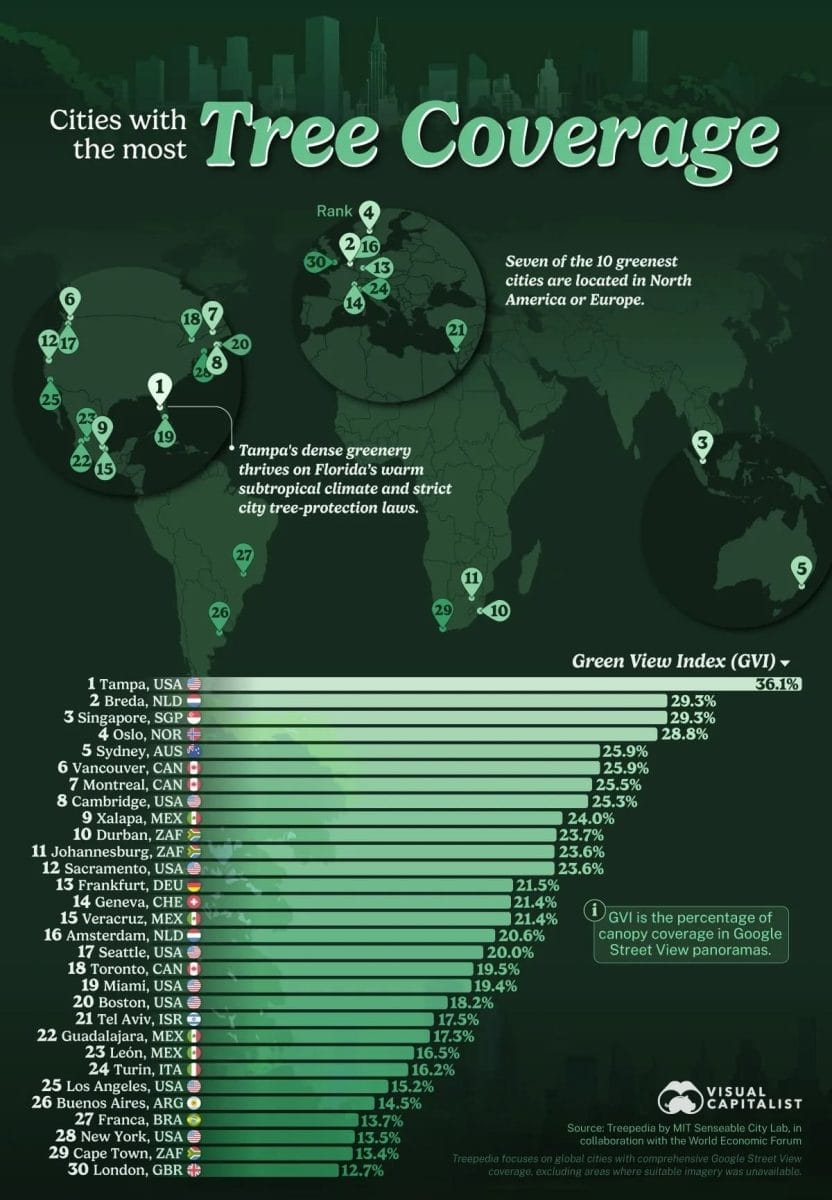
- The Treepedia project by the MIT Senseable City Lab and the World Economic Forum compared cities around the world using the Green View Index —the share of tree cover visible from street level in Google Street View panoramas, rather than from a bird's-eye view, writes Naked-science.
- First place went to the American city of Tampa; second place was shared by Breda and Singapore (29.3%), third by Oslo (28.8%); five of the twelve leading cities are located in North America.
- The methodology deliberately differs from measuring park area: a city may have extensive green spaces and still receive a low score if the trees in those parks are not visible from the sidewalks and roads where people actually move around.
- Street trees cool the urban environment through shade and moisture evaporation, reduce air pollution, and retain rainwater—that is, they work as natural infrastructure for adapting to heat, not just an aesthetic decoration.
Why street level specifically, and not a map of the city
The Green View Index underlying the ranking takes values from 0 to 100 and uses computer vision to analyze what share of the visible space at a given point is occupied by tree cover. This is a fundamentally different view of greening than standard city reports on the area of parks and public gardens: a tree hidden behind a fence or deep in a courtyard has no effect on the experience of a person walking along the neighboring sidewalk under the scorching sun. The authors of the ranking specifically emphasize that Treepedia covers only a limited set of major cities with available panoramic imagery, so the final list is a comparison within the project's database, not an exhaustive ranking of all cities on the planet.
The leader's secret—not only climate, but also care
Tampa's subtropical climate creates favorable conditions for tree growth, but climate alone is not enough—sustainable greening requires constant care. The city has sustainability programs in place, and the Green Team is involved in tree planting and other environmental projects, with a particular emphasis on preserving already mature trees: restoring lost tree cover is a process that stretches over years. The felling and compensatory planting of protected trees in the city are strictly regulated, which makes it possible to preserve greenery as further development proceeds.
Kazakhstani cities have already shown the same pattern
What the global ranking formulates as a general principle, Kazakhstani studies have already confirmed with concrete figures based on local material. We have already written that the Pavlov Analytics analytical center studied the perceived temperature of all 49,538 buildings in Astana and found a difference of up to 16°C between the hottest and coolest sites in the city on the same day—the hottest was in the airport area with its concrete and complete absence of trees, the coolest was by the Yesil River, where greenery and water work as a natural air conditioner. A similar study for Almaty produced an even more contrasting result: the difference between the hottest building in the city—the Grand Park shopping center with its huge flat roof and parking lots without a single tree—and the cool dacha areas in the foothills reached 19°C.
Why this is especially relevant right now
The topic of the urban heat island is not abstract urbanism, but an issue directly linked to human lives. Hunn.kz wrote that the anomalous heat that swept across 27 European countries at the end of June 2026 led to 10,650 excess deaths in just one week—and noted at the time that for Central Asia the risks are even higher, since the region's healthcare systems and urban infrastructure are less adapted to extreme temperatures, and insufficient urban greening was directly named as one of the vulnerability factors. That is precisely why Kazakhstani studies of the heat island and the global ranking of street greening are not parallel but mutually reinforcing data: the former show the scale of the health consequences of heat, the latter provide a concrete, practically applicable tool for mitigating those consequences.
The same logic at different scales
It is telling that Kazakhstani and global data obtained by completely different methods point to the same cause: not the total amount of greenery in a city as such, but its physical presence precisely where people are—on sidewalks, near bus stops, along roads. Neither Astana nor Almaty participates directly in the Treepedia database, but the logic of the heat island recorded in Kazakhstani studies is exactly the same phenomenon that the international ranking attempts to measure and compare among cities around the world.
Author's conclusion
Both levels of data—the global Treepedia ranking and the local Kazakhstani measurements by Pavlov Analytics—converge on one practical conclusion: greening works as a tool for reducing heat only when trees grow not in remote parks but directly along the routes of people's everyday movement. For Kazakhstani cities, where the temperature difference between individual buildings already reaches 16–19 degrees on the same day, this is not an abstract recommendation but a concrete and measurable guideline for urban planning—at the level of specific streets and blocks, rather than citywide declarations about greening.

Comments ()