Kazakhstan completes demarcation of the Semipalatinsk nuclear safety zone borders.
35 years after closing the Semipalatinsk nuclear test site, Kazakhstan completed long-term work to clearly divide its territory into hazardous and safe zones.
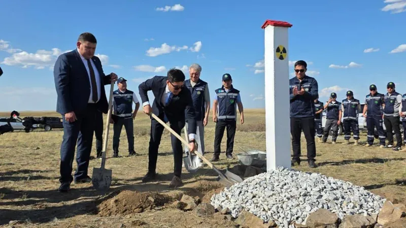
The result of this work is nearly 10 thousand square kilometers of land that can now be gradually returned to economic use, Inform.kz reports.
The gist in brief
- On August 28, 2026, the last boundary marker was installed on the territory of the former Semipalatinsk nuclear test site, completing the demarcation of the Semipalatinsk nuclear safety zone.
- Of the more than 18,000 sq. km of surveyed territory, about 8,300 sq. km retain radiation risks and require a special usage regime, while approximately 10,000 sq. km have been recognized as safe and can be gradually returned to economic use.
- The legal basis for the new approach was laid by the law "On the Semipalatinsk nuclear safety zone," adopted in 2023; the scientific and technical foundation for zoning was provided by the National Nuclear Center of the Republic of Kazakhstan.
- The event is timed to the 35th anniversary of the closure of the test site and is intended to create conditions for the socio-economic development of the Abai, Pavlodar, and Karaganda regions.
From a test site to a zone with clear zoning
Deputy Chairman of the Atomic Energy Agency of the Republic of Kazakhstan Gumar Sergazin outlined the essence of the changes: "The formation of the Semipalatinsk nuclear safety zone is a fundamentally new stage in state policy regarding the territory of the former test site. Today our task is to clearly divide the territories by risk level: hazardous areas must remain under reliable state control, while lands whose safety has been confirmed by scientific research should be gradually returned to economic use."
This is a fundamental change in approach: for decades, the entire territory of the former test site was perceived as a single closed zone, but now it has been officially divided into areas with a clearly defined legal status depending on the actual level of radiation hazard.
What has been happening all these years
The demarcation of boundaries is the visible culmination of a far more extensive and lengthy effort. After the closure of the test site, Kazakhstan carried out a large-scale set of measures to bring the territory to a safe state: test infrastructure was eliminated or neutralized, major projects in nuclear non-proliferation were implemented, and the National Nuclear Center conducted a comprehensive radioecological survey of an area exceeding 18,000 sq. km. It is the results of these years of research that formed the basis for deciding which areas can be recognized as safe and which still require a special regime.
What this means for the regions
The formation of a zone with clear zoning is not only a matter of environmental safety but also an economic opportunity for the adjacent territories. The return of nearly 10,000 sq. km of land to economic use should create conditions for the socio-economic development of three regions at once — the Abai region, Pavlodar region, and Karaganda region — where the territory's status as part of the closed test site previously precluded any economic use, even if a specific plot posed no real radiation hazard.
Author's conclusion
The completion of the demarcation of the Semipalatinsk zone's boundaries is a rare example of how scientific data accumulated over decades is ultimately converted into a concrete legal and economic decision. For Kazakhstan, which is simultaneously developing the nuclear energy of the future — from the plant near Balkhash to the IAEA's international low-enriched uranium bank — working with the legacy of the past nuclear project remains an equally significant part of the country's overall nuclear agenda. The emergence of clear, legally enshrined safety boundaries is what distinguishes systematic state policy from a one-off symbolic gesture.


Comments ()