NOAA raises probability of record El Niño to 69%
The developing super-El Niño story we've tracked since summer gained new confirmation from the top U.S. climate agency.
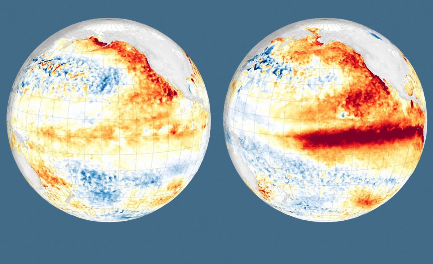
The National Oceanic and Atmospheric Administration (NOAA) said the probability of a record-breaking event has risen to nearly 70% — and this is no longer a cautious forecast, but the result of a sharp acceleration of the process itself.
The gist in brief
- According to the NOAA forecast of August 13, 2026, the probability that the developing El Niño will become the strongest since records began in 1950 has risen to nearly 69%.
- The probability of a "very strong" El Niño between October and December 2026 has reached 90–95% — up from 81% in the July forecast.
- The sea surface temperature anomaly in the key Niño 3.4 region is expected to exceed 2.66°C, higher than the super El Niño of 1982–1983 (2.4°C), which held the record for more than four decades.
- At depth in the Pacific Ocean, NOAA has recorded local temperature anomalies of up to +10°C — a signal that the event will continue to intensify through the end of the year.
How El Niño strength is measured
The intensity of El Niño is determined by the deviation of sea surface temperature from the norm in the reference region of the tropical Pacific — the so-called Niño 3.4 region — averaged over a three-month period to filter out short-term fluctuations. This indicator, officially called the Relative Oceanic Niño Index (RONI), has been maintained by NOAA since 1950. The sharp upward revision of the forecast is not due to a new methodology, but to the fact that the event is developing faster than expected: models almost unanimously show a peak in late autumn — early winter at levels exceeding previous calculations.
Weather impacts
NOAA warns that the strengthening El Niño increases the likelihood of weather scenarios typical of the phenomenon, especially in autumn and winter, when its influence on weather in the Northern Hemisphere peaks. In the United States, this means unusually wet conditions from California through the southern states to Florida, and a milder and drier winter across parts of the Midwest. El Niño also increases the likelihood of tropical cyclones in the Pacific while suppressing hurricane activity in the Atlantic — it was the strong El Niño that was the main reason for NOAA's forecast of a weaker-than-usual Atlantic hurricane season this year.
Continuation of a story we have already covered
The fresh NOAA forecast is a direct development of the storyline we have been tracking all summer. The African Development Bank previously estimated the damage to the most vulnerable African countries from the same event at $10–20 billion, while for Central Asia, including Kazakhstan, forecasts point not to drought, but to an elevated risk of precipitation and heatwaves. Separately, climatologists warned of a record rise in sea level off the coast of California toward the end of the year — a forecast that the new, more confident statement from NOAA only reinforces. The same episode is also accelerating the destruction of Alpine glaciers — the closure of classic routes on Mont Blanc and the Matterhorn this summer is described by experts as a climate signal, directly comparable to what is happening to the glaciers of the Tien Shan and the Dzungarian Alatau, which feed the rivers of southern Kazakhstan.
Author's conclusion
The rise in probability from "one of the strongest events in history" to "nearly 70% chance of an absolute record" within a matter of weeks shows how rapidly the process itself is now unfolding in the Pacific Ocean. NOAA explicitly warns: record strength does not automatically mean more destructive consequences in every corner of the planet — but it does significantly increase the likelihood of El Niño-typical scenarios precisely where they usually manifest. For everyone following this story — from African farmers to residents of the Central Asian plains — the coming weeks will show whether the most alarming of NOAA's forecasts come true.

Comments ()